

Backpacker trek
Huayhuash Trek 8 days
The Huayhuash Trek 8 days is a challenging but rewarding 92-kilometre circuit for fit, acclimatized hikers. Experience Carhuacocha, the 3 lakes viewpoint, Trapecio Pass, San Antonio Pass and Jahuacocha. Our local, experienced team manages meals, camps and logistics, while pack animals carry your main luggage.
What trekkers say
Read all reviewsNext departures
See all dates1 confirmed departure currently available
- All Huayhuash circuit highlights in 8 days
- Hike with only your daypack, all equipment and luggage carried for you
- Licensed, English speaking guides with first-aid training
- Experience Carhuacocha, the three-lakes viewpoint, Trapecio Pass, San Antonio Pass and Jahuacocha.
Confirmed means the departure is set to run. When a departure is still forming, we show exactly how many more trekkers are needed.
October 2026
November 2026
How forming departures, deposits and refunds work
A green confirmed label means this departure is set to run and you can book your place. We will not cancel it because too few people join. Only exceptional safety, legal or other events beyond our reasonable control could require a change or cancellation. If we cancel before the trek starts, you can choose another available date or receive a full refund of what you paid for the trek.
We confirm or cancel a forming departure no later than 3 days before its scheduled start. If we cannot run it and you do not want another available date, we refund 100% of what you paid for that trek booking. If you cancel before our decision, our normal traveler cancellation terms apply.
Booking for two or more? Ask us about opening a new date. We can promote it to other trekkers. We may also offer a semi-private option at a price agreed with you in advance. A requested date is confirmed only when we confirm it in writing.
For bookings made more than 15 days ahead, the deposit is 50% and the balance is due 15 days before departure. Bookings accepted within 15 days require full payment when booked.
Included
Guiding & staff
- Briefing at our Andes Treks office in Huaraz the evening before the trek
- English-speaking, licensed Huayhuash guide
- Assistant(s) for added safety (from 8+ persons)
- Professional mountain cook
- Donkey drivers and donkeys
Equipment
- 4-season Doite tent (per 2 persons)
- −11°C down sleeping bag (limit)
- Comfortable R-value 4.6 sleeping pad
- Foam mattress (R-value 1.8+) underneath the sleeping pad
- Sea to Summit mummy liner for extra hygiene
- Dining tent, tables, stools and other camping equipment
- Personal duffle bag (up to 5 kg)
Food & water
- All meals prepared with fresh, local ingredients
- Breakfast and coffee, lunch and dinner
- Daily tea-time and snacks provided
- Safe, boiled drinking water throughout the trek for refill (from day 2)
Logistics
- Pick up at your stay in Huaraz (city center)
- Transport Huaraz – start point
- Transport end point – Huaraz
- Drop off at your stay in Huaraz
- Luggage storage in Huaraz at our office
Safety
- Emergency horse
- Radio communication
- First aid kit & evacuation protocol
- Emergency oxygen
- Stretcher
Excluded
- Huayhuash entrance fees paid directly to local communities (approximately 280 Peruvian soles)
- Trekking poles (highly recommended, available for rent)
- International and domestic flights
- Personal travel insurance (highly recommended)
- Hotel nights in Huaraz before and after the trek
- Personal trekking clothing and footwear
- Camping pillow
- Additional snacks and personal drinks
- Alcoholic beverages
- Tips for guides, cook, and support staff
- Personal medical expenses
- Any costs caused by early departure from the trek
- Extra services not listed under “Included”
These optional extras are not included in the trek price. You choose them inside the WeTravel booking process: after you click Book now, the booking form lists every extra below with its price, and you add the ones you want before you pay.
| Extra | Price (USD) |
|---|---|
|
Entrance to Huayhuash region
Or pay 280 soles at the briefing... This add-on covers the required entrance and community access fees for the Huayhuash region throughout your selected trek. The Huayhuash Circuit crosses land managed by several local Andean communities. These entrance fees support the communities that maintain the trails, campsites, access roads and natural areas used during the trek. The exact fees depend on your chosen itinerary, the number of trekking days and the communities visited. By adding this option, Andes Treks will arrange and manage the applicable entrance payments for your complete itinerary, so you do not need to carry separate amounts or organize payments at each checkpoint. Recommended for a smooth and worry-free trekking experience. Subject to availability and possible changes in local community fees or access conditions. |
$99.00 |
|
Professional trekking poles
Rent a pair of professional trekking poles for the full duration of your Huayhuash trek... The Huayhuash Circuit includes steep ascents, long descents, rocky trails, loose gravel and uneven mountain terrain. Trekking poles provide additional balance and stability while helping to reduce pressure on your knees, ankles and leg muscles. They are especially useful during long downhill sections, high mountain passes and wet or slippery conditions. The poles are adjustable, lightweight and suitable for multi-day trekking at high altitude. We provide professional trekking poles from trusted brands such as Leki or Black Diamond. The exact brand and model provided may vary. Your trekking poles will be provided before departure and can be used throughout your complete trek. Highly recommended for greater comfort, stability and confidence on the trail. Subject to availability. |
$40.00 |
|
Daypack 32L
Rent a comfortable 32-litre daypack for the full duration of your trek... A 32L daypack offers enough space for the essential items you need during each trekking day, including water, snacks, rain protection, warm layers, sun protection, personal medication, a camera and other small belongings. The practical size makes it spacious enough for mountain conditions without being unnecessarily large or heavy. It is ideal for carrying your daily essentials while the main luggage allowance is transported separately according to the conditions of your selected trek. The daypack will be provided before departure and remains available for your complete Huayhuash itinerary. A convenient choice for travelers who do not want to bring or purchase their own trekking backpack. Subject to availability. The exact brand, model and design may vary. |
$32.00 |
|
Private 4-seasons tent
Enjoy additional privacy and personal space with your own tent throughout the trek... Standard accommodation is normally based on two travelers sharing one tent. By selecting the private tent add-on, you will have a tent reserved exclusively for your individual use for every camping night included in your itinerary. A private tent gives you more room to organize your belongings, change clothes and relax comfortably after each trekking day. It is especially recommended for solo travelers, light sleepers or anyone who values greater privacy during a multi-day mountain adventure. Your private tent will be transported, installed and packed away by the trekking team at each campsite. Upgrade your trek with more privacy, space and comfort at camp. Subject to availability. The exact tent brand, model and size may vary. |
$72.00 |
|
Premium sleeping bag -18 degrees celsius
Rent a premium cold-weather sleeping bag for the full duration of your Huayhuash trek... Nights in the Huayhuash mountains can be extremely cold, particularly at high-altitude campsites. This premium sleeping bag is designed for cold mountain conditions and has a temperature rating of approximately -18°C limit. It provides significantly more warmth and insulation than a standard trekking sleeping bag, helping you rest and recover properly between demanding trekking days. The sleeping bag is lightweight for its warmth level and suitable for multi-day camping in the high Andes. Your sleeping bag will be prepared before departure and available for every camping night included in your trek. Please note that temperature ratings are general manufacturer guidelines. Individual comfort can vary depending on weather conditions, altitude, clothing, sleeping mat and personal sensitivity to cold. One of the most valuable comfort upgrades for a warm and restful night in the mountains. Subject to availability. The exact brand and model may vary. |
$48.00 |
Camping equipment provided for Huayhuash Trek 8 days.
Every item shown below is included in your trek price.
Doite Pro Aconcagua 4-season tent
A strong 4-season expedition tent built for demanding mountain conditions. Designed to provide reliable protection against heavy rain, strong winds, and low temperatures, with comfortable space for up to three people, but shared per 2 persons.
IncludedMarmot down sleeping bag – limit -11°C
A warm and lightweight sleeping bag filled with 650-fill-power duck down, ideal for cold nights in the Andes. ISO tested: Comfort -5°C / Limit -11°C.
IncludedR4.6 Inflatable sleeping pad
A lightweight insulated sleeping pad designed for extra warmth and comfort during cold mountain nights. It is placed on top of the foam sleeping pad for better insulation and a more comfortable sleep.
IncludedR1.8+ Foam sleeping pad
A durable closed-cell foam sleeping pad that provides reliable insulation from the cold ground and cannot be punctured. It is placed underneath the inflatable pad for extra warmth, protection, and comfort.
Included- Huaraz – Pocpa - Cuartelhuain - Janca
- Janca – Paso Carhuac – Carhuacocha
- Carhuacocha – 3 lakes viewpoint – Huayhuash
- Huayhuash – Trapecio Pass – Campo Elefante
- Campo Elefante – San Antonio Pass – Huayllapa
- Huayllapa – Gashpapampa
- Gashpapampa – Jahuacocha
- Jahuacocha – Llamac – Huaraz
Daily elevation profile for Huayhuash Trek 8 days.
- 550 m | 1804 ft
- 392 m | 1286 ft
- 735 m | 2411 ft
- 724 m | 2375 ft
- 554 m | 1817 ft
- 1,290 m | 4232 ft
- 534 m | 1751 ft
- 358 m | 1174 ft
Experience the Huayhuash Trek 8 days
The Huayhuash Trek 8 days is a demanding high-altitude circuit through one of Peru’s most spectacular mountain ranges. Covering approximately 95 kilometres, this route connects turquoise lakes, remote valleys, traditional Andean communities and a series of mountain passes approaching 5,000 metres. It is designed for fit, well-acclimatized hikers who want to experience the defining landscapes of the Cordillera Huayhuash within a limited timeframe. Compared with longer circuits, the route moves at a faster pace and requires longer hiking days. In return, you experience places including Carhuacocha, the Siula lakes viewpoint, Trapecio Pass, Huayllapa and Jahuacocha. Throughout the trek, our local team manages the camps, meals and group equipment. Pack animals carry the main luggage, allowing you to hike with a daypack.
What to expect on the 8 day Huayhuash trek
Most days involve approximately six to eight hours of hiking across steep, uneven and high-altitude terrain. The route regularly stays above 4,000 metres and crosses several passes above 4,700 metres. This is a remote camping trek. Nights are spent beside mountain lakes or in wide Andean valleys, far from roads and towns. Conditions are basic compared with a hotel-based trip, but the camps provide a comfortable place to rest, eat and recover after each hiking day. You can expect:
- Approximately 92 kilometres of hiking
- Several high passes between 4,700 and 5,000 metres
- Remote camps surrounded by mountains and lakes
- Main luggage transported by pack animals
- Meals prepared by the expedition team
- Support from local guides and muleteers
- Long ascents, steep descents and changing mountain weather
Huayhuash route highlights
The journey begins with a drive from Huaraz into the Cordillera Huayhuash. From the trailhead, the route enters a landscape of glaciated peaks, high grasslands and isolated farming communities. Early in the circuit, you trek towards Mitucocha and Carhuacocha. From Carhuacocha, the trail approaches one of the best-known viewpoints in the range: the three turquoise lakes beneath Yerupajá and Siula Grande. Siula Grande became internationally known through the book and film Touching the Void. The route continues across Siula and Trapecio passes before descending towards the Cutatambo Valley and Huayllapa. The final stages cross the Tapush and Yaucha areas before reaching Jahuacocha, where snow-covered peaks rise above the lake. On the final day, you cross the last pass and descend towards the road, where private transport returns you to Huaraz. The published itinerary represents the planned route. Campsites, trails and daily stages may change because of weather, trail conditions, safety considerations or local restrictions.
How difficult is the Huayhuash Trek 8 days?
The Huayhuash Trek 8 days is challenging. Its difficulty comes from the altitude, consecutive hiking days, steep terrain and faster pace compared with longer versions of the circuit. You should be comfortable hiking for six to eight hours on consecutive days. Previous multi-day hiking experience is strongly recommended. You do not need technical climbing skills, but good cardiovascular fitness, strong legs and experience on mountain trails will make the trek safer and more enjoyable. Pack animals transport the main luggage, so you normally carry only your daypack with water, extra clothing, sun protection and personal essentials. This route is not recommended as a first high-altitude trek without suitable preparation and acclimatization.
Altitude and acclimatization
The trek begins at approximately 4,180 metres and reaches close to 5,000 metres at its highest point. Most camps and hiking days remain above 4,000 metres. We recommend spending at least three to four days in Huaraz before departure. Use this time for progressive acclimatization hikes rather than immediately attempting the highest available day hike. Your body needs time to adjust, even if you are physically fit. Before travelling, consider speaking with a medical professional about high-altitude trekking and any personal health concerns. During the trek, always tell your guide if you develop a persistent headache, nausea, unusual fatigue, dizziness or difficulty breathing. Fitness helps with the physical demands, but it does not prevent altitude illness. Proper acclimatization remains essential.
Training for the trek
Prepare with regular hiking, cardiovascular exercise and leg-strength training. Whenever possible, complete consecutive hiking days with elevation gain and a light backpack. Useful preparation includes:
- Long walks or hikes on uneven terrain
- Uphill training and stair climbing
- Squats, lunges and other leg-strength exercises
- Cardiovascular training several times per week
- Hiking with the boots and daypack you will use in Peru
Your hiking boots should be comfortable and already broken in before the trek.
Weather and best time to trek
The main trekking season runs from May to September. These months generally bring drier conditions and better visibility, although weather in the Andes can change quickly at any time. Days may feel warm in direct sunlight, while evenings and nights at high camps can fall below freezing. Strong ultraviolet exposure, wind, rain, hail and occasional snow are possible. April and October are transitional months. They can offer good conditions but carry a greater chance of rain and cloud. The wetter period generally runs from November through March, when muddy trails, high rivers and reduced visibility make the circuit less predictable. Always prepare for both strong sun and cold, wet mountain weather.
Who is this trek for?
This trek is best suited to hikers who:
- Have good general fitness
- Are comfortable with long mountain days
- Have previous multi-day hiking experience
- Can manage basic remote camping conditions
- Have enough time to acclimatize in Huaraz
- Want a demanding Huayhuash experience within eight days
If you prefer a slower pace and more recovery time, consider one of the longer Huayhuash circuits. If you are unsure which version is right for you, contact our Huaraz team before booking. We can help you compare the routes honestly based on your experience, available time and acclimatization plan.
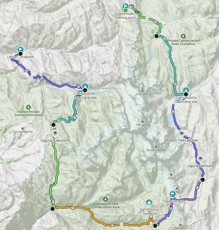
Huayhuash Trek 8 days map
Recommended packing list for Huayhuash Trek 8 days.
Clothing
Base layers
- Long-sleeve moisture-wicking base layer
- Thermal base layer for cold nights
- Short-sleeve breathable shirts
- Light long-sleeve sun protection shirt
Insulation
- Insulated jacket (down or synthetic)
- Fleece or mid-layer jacket
Outer layers
- Waterproof rain jacket
- Rain pants (especially November to March)
- Windproof softshell jacket
Hiking clothing
- Trekking pants
- Quick-dry pants or shorts
- Warm socks for evenings
- Breathable hiking socks
- Liner gloves
- Warm hat and light beanie
- Multifunctional headwear (buff or similar)
Footwear
- Waterproof hiking boots with good ankle support
- Lightweight shoes or sandals for camp
- Gaiters (optional, useful in snow or mud)
Sleeping & trek gear
- Daypack with rain cover (available to rent)
- Waterproof duffle bag (provided by Andes Treks)
- Trekking poles (highly recommended, available to rent)
- Headlamp with spare batteries
- Microfiber towel
Personal equipment
- Sunglasses with UV protection
- Sunblock and lip balm with SPF (30+)
- Insect repellent
- Reusable water bottle or insulated vacuum bottle
- Portable power bank and charging cables
- Personal toiletry kit and wet wipes
- Small dry bags for electronics
Health & safety
- Personal first aid kit
- Personal medication
- Blister treatment and foot care supplies
- Sunscreen for high altitude exposure
Others
- Cash in Peruvian soles for community fees and tips
How booking works
- 1
Check your departure date
Review our live status first. Confirmed means the departure is set to run; forming dates show exactly how many more trekkers are needed.
- 2
Book your trek
Reserve securely through WeTravel. For bookings made more than 15 days ahead, the deposit is 50% and the balance is due 15 days before departure. Bookings accepted within 15 days require full payment when booked.
- 3
We contact you personally
Our Huaraz team confirms your selected departure and trip details directly with you.
- 4
Prepare with confidence
Receive your final briefing, packing guidance, and meeting details.
Detailed itinerary Huayhuash Trek 8 days

Today
We leave Huaraz before dawn and drive south through the Santa River valley toward Chiquian. Along the way, the first distant views of Yerupajá reveal the scale of the Cordillera Huayhuash. Afterwards, we continue by mountain road through Llamac and Pocpa to Cuartelhuain at 4,170 meters. Here, the hiking section begins with a steady ascent across open puna grassland. Because this is the first day at high altitude, we keep a controlled pace and take regular hydration breaks. Soon, the trail reaches Punta Cacanan at 4,671 meters, the first high pass of the circuit. From the pass, broad valleys open on both sides of the ridge. Finally, we descend toward Janca, the campsite near Laguna Mitucocha. Meanwhile, Rondoy, Jirishanca, and Ninashanca form a dramatic skyline above camp. As a result, the first day combines a long scenic transfer with a short but important acclimatisation hike.

Today
After breakfast, we leave Janca and follow the valley south. At first, the trail climbs gradually through puna grassland, where grazing alpacas and mountain streams accompany the route. Next, the gradient becomes steeper as we approach Punta Carhuac. From the pass at 4,612 meters, the eastern faces of Yerupajá and Siula Grande rise directly across the valley. Therefore, this is one of the first major panoramic moments of the Huayhuash trek. Afterwards, we descend on a clear trail toward Laguna Carhuacocha. As the lake appears, the ice-covered summits of Yerupajá, Yerupajá Chico, Jirishanca, and Siula Grande reflect across the water in calm weather. Finally, we reach camp beside Carhuacocha at 4,155 meters. Because the hiking distance is moderate, the afternoon offers time to rest, photograph the lake, and prepare for the demanding Siula Pass stage.

Today
We start beside Laguna Carhuacocha and follow the shoreline before climbing into the glacial valley. Soon, the route passes the famous chain of turquoise lakes: Gangrajanca, Siulacocha, and Quesillococha. Next, a steep ascent leads to Mirador Tres Lagunas. From this viewpoint, the three lakes align below the ice walls of Yerupajá and Siula Grande. As a result, this is often considered the signature view of the entire Huayhuash circuit. The trail then continues upward across loose, high-altitude terrain to Punta Siula at 4,796 meters. Because the ascent is sustained and parts of the route are steep, careful footing and a steady rhythm are essential. Afterwards, we descend past Laguna Carnicero and enter a wider valley. Finally, we arrive at Huayhuash camp at 4,342 meters, surrounded by open grassland and views toward Trapecio and the southern peaks.

Today
We leave Huayhuash camp and walk south toward the high basin below Nevado Trapecio. At first, the ascent is gradual across broad grassland. However, the route soon becomes steeper and rockier as it approaches the pass. Next, we climb to Punta Trapecio at 5,015 meters, the highest point of this day. From the pass, the views extend across Trapecio, Puscanturpa, Cuyoc, and the deep valleys on the western side of the range. Therefore, clear weather makes this one of the most dramatic crossings of the eight-day circuit. Afterwards, we descend carefully through moraine and high alpine terrain. The path gradually reaches softer ground as Elefantepampa opens below. Finally, we arrive at camp at 4,510 meters. Because both the altitude and terrain are demanding, this day requires strong acclimatisation, warm layers, and deliberate pacing.

Today
We leave Elefantepampa and begin a steep climb toward Mirador San Antonio. Although the distance to the high point is short, the thin air and loose terrain make the ascent intense. Soon, we reach the viewpoint at 5,006 meters. From here, the panorama includes Cuyoc, Puscanturpa, Trapecio, Siula Grande, Yerupajá, Sarapo, and Jurao. Below, the Cutatambo and Huanacpatay valleys reveal the long descent that follows. Afterwards, we descend carefully from the pass and continue through increasingly green terrain. As altitude decreases, alpine rock gives way to grassland, shrubs, waterfalls, and cultivated slopes. Finally, the trail reaches Huayllapa at 3,505 meters, the only village overnight on this itinerary. Because the segment loses more than 1,500 vertical meters and is the longest day of the trek, it is demanding even though most of the route is downhill.

Today
We leave Huayllapa and begin the longest sustained ascent of the itinerary. At first, the trail follows a green valley past fields, waterfalls, and small woodland areas. Next, we climb steadily through Huatiac and return to the high puna. Because the route gains almost 1,300 meters, a slow rhythm is essential. The landscape gradually opens toward Diablo Mudo and the western edge of the Huayhuash range. Soon, we reach Punta Tapush at 4,778 meters. From the pass, we look toward Laguna Susococha and the glaciated summit of Diablo Mudo. Afterwards, a short descent leads across open grassland to Gashpapampa. Finally, we set camp at 4,514 meters. Although this day finishes higher than it begins by more than 1,000 meters, the gradual profile and improving views make the climb especially rewarding.

Today
After breakfast, we leave Gashpapampa and climb toward Punta Yaucha. The trail crosses open puna with wide views toward Diablo Mudo and the western summits of the Huayhuash range. Next, we reach the pass at 4,887 meters, the highest point of the day. From the ridge, the northern skyline returns into view, including Rondoy, Jirishanca, Yerupajá, and Rasac. Afterwards, we follow a descending traverse toward the Jahuacocha viewpoint. Suddenly, the turquoise waters of Jahuacocha and Solterococha appear below the snow-covered peaks. Therefore, this is one of the strongest final panoramas of the circuit. Finally, we descend to the lakeside camp at 4,064 meters. Because the route loses nearly 1,000 meters after the pass, trekking poles help protect the knees on the long descent.

Today
We leave Laguna Jahuacocha after breakfast and begin the final traverse of the circuit. At first, the trail rises gently above the Huayllan valley, giving one last view of the lake and the peaks of Rondoy, Jirishanca, Yerupajá, and Rasac. Soon, we reach Pampa Llamac at 4,292 meters. From this final viewpoint, the northern Huayhuash skyline stretches behind us. Therefore, it is an ideal place for a last group photo before leaving the high mountains. Afterwards, the trail descends steadily through dry grassland and scattered quenual woodland. As we lose altitude, the climate becomes warmer and the village of Llamac appears below. Finally, we arrive in Llamac at 3,256 meters, where private transport meets the group. We then drive through Chiquian and return to Huaraz, completing the eight-day Huayhuash circuit.
Distances, hiking times, routes and arrival times are estimates. Your guide may adjust the itinerary due to weather, trail conditions, safety considerations or the needs of the group.
Real experiences
Huayhuash Trek 8 days reviews
A serious trek deserves serious preparation